You don’t appreciate just how big Poole Harbour really is until you row from Pottery Pier to the little beach in the fishing boat marina.
That’s 1.3 nautical miles (Poole Harbour being the second biggest natural harbour in the world – second only to Sydney, apparently).
I row at two knots – but then, I have all the time in the world…
Rowing back and thinking about last weekend’s trip to Jersey to visit my son Olly and his family, it seemed astonishing that it is 40 years since I used to ferry Olly and his younger brother George across the harbour in a dramatically overloaded inflatable.
In those days, it was from the mooring off Brownsea Island to the Lilliput Yacht Station (now a block of flats).
Admittedly, I wasn’t rowing; we had a Suzuki 2hp, and the inflatable was a Tinker Tramp with double buoyancy chambers.
But we were definitely overloaded – particularly on the outward passage. The boys had their bags on their laps in the hope of keeping them dry. I needed a free hand to steady the pile of victuals as we navigated the Middle Ship Channel with its freighters and ferries. If we met the pilot boat, everything was going to get soaked anyway.
“Did you ever think that was just a teeny bit irresponsible?” I asked over the Braye beach café’s crab linguine.
“Not at all,” said Olly. “I assumed you knew what you were doing.”
“Ah, such faith!”
“Until you got me up in the middle of the night to look for rocks…”
I had rather forgotten about this. But now it’s out there, I suppose the story must be told…
It must have been a few years later because Olly was about 14 and George 12. I had delivered Largo to Plymouth in anticipation of a West Country cruise without having to spend 18 hours bashing them across Lyme Bay into a Force 6. But as we travelled down on the train, the sun shone, and a northwesterly 4 promised a perfect passage to the other side.
“If we set off as soon as we arrive, we can be in Morgat tomorrow in time for a late dinner in Café du Port,” I enthused.
Olly and George were up for it.
Isn’t it amazing how trusting children can be?
Suffice it to say, dinner the following night did not find us diving into cauldrons of moules. Instead, I suspect it might have been something rather hurried, like a handful of biscuits as I searched for Les Plâtresses in the gathering dusk.
It was sometime in the middle of the night when both boys were tucked up in their sleeping bags, and the night was as black as only a moonless night can be when you have neglected to look up the time of moonrise, that the Grande Viotière (Fl. R. 4s.) seemed to get itself mixed up with the Tournant et Lochris (Fl. (2) R. 6s.)
Somehow, this did not seem the moment to go below to get the Seafix out of its bracket and start looking up frequencies for radio beacons (NW France).
Olly took up the story, aware that my grandson Benedict’s opinion of me was shrinking with each unfortunate turn of events.
“You woke me up and said you needed me in the cockpit to keep a lookout for rocks,” Olly went on, rather in the manner of midshipman Hornblower pointing out to the First Lieutenant that the French were now behind them as well as in front … and on both sides…
Well, I had suspected something might be wrong because a fishing boat had spent an awfully long time shining a searchlight at me – presumably wondering what a single navigation light was doing where no light had a right to be.
And the searchlight must have ruined whatever night vision age and nature had left me, because, no sooner did Olly poke his head out of the companionway than he said: “There are rocks over there…”
“Where?”
“Just over there. You can see the waves breaking on them.”
It didn’t seem the moment to argue. I spun Largo on a sixpence and headed straight for the fishing boat – presumably, he knew where he was…
It was breakfast we had in Morgat instead of dinner– and a lovely week in the Îsles de Glènan. The unfortunateness was all forgotten on the trip back – setting out as we did in broad daylight with courses and transits all drawn out carefully on the chart.
Anyway, it shouldn’t happen again. Now, I’ve got Navionics on two phones and a tablet – and the Garmin plotter… and two VHFs with GPS…
Just as well, too. I’ve looked up radio beacons (NW France), and they don’t seem to be there any more…
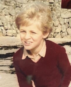
Olly, then.
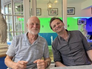
…and now.

…and Benedict.
U haven’t navigated until you have used an old sock on a piece of string and a watch as log plus the Townsend ferry or an RAF airways chart for plotting!
Yes! Navionics is our beacon today too!!
We used to have only a compass our walker log and seafahrer dept indicator
Than rhe Seafix wich was better than the.transistor radio with a long wave functon but we never got a proper position from it. It was nice for homing on a beacon but that was all.
The Seafix got me into Falmouth once – thick fog and a flat calm, sitting on the forehatch (away from the engine interference) taking running fixes.