For all those people who asked when I was going to write another book, it turns out the answer was: Not until I was clocking a hundred miles a day without touching the helm or the sheets.
Sure enough, the Atlantic crossing by the trade wind route provided the perfect motivation – there wasn’t anything else to do.
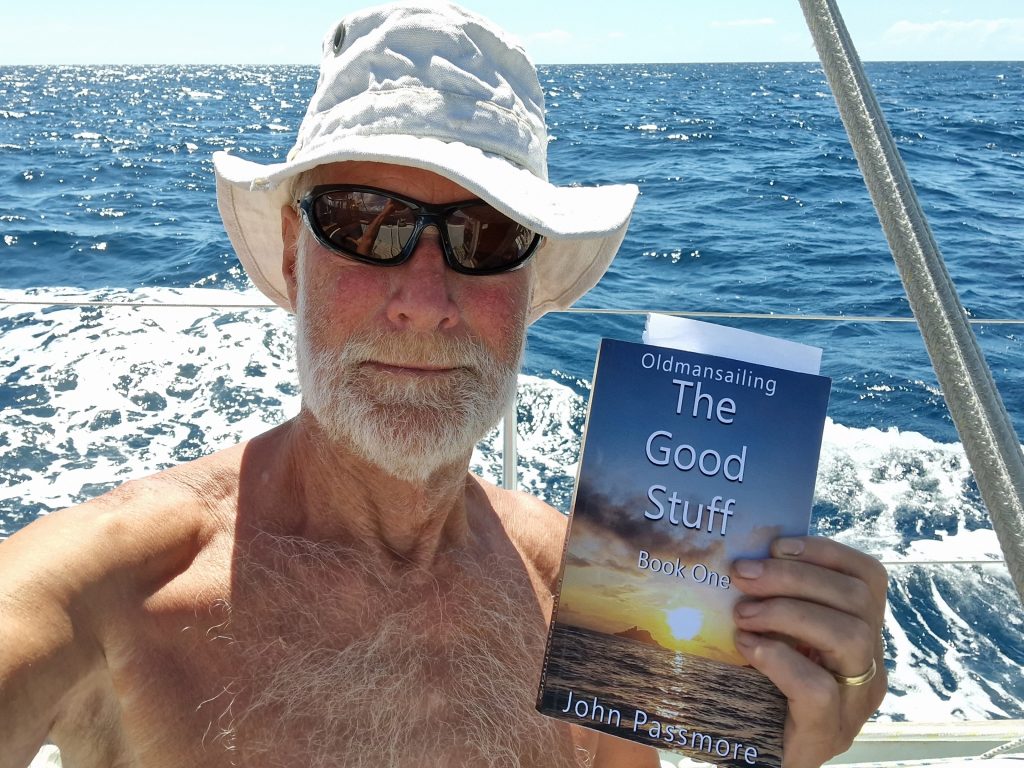
And so I am pleased to present The Good Stuff.
I won’t describe it here because there’s an extensive introduction explaining how it came about – and of course, the blurb on the Amazon page.
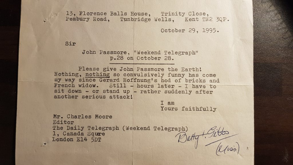
But already it has its first review: From Betty Gibbs of Tunbridge Wells, who wrote to the editor of the Daily Telegraph with fulsome praise for the episode involving the dog, the Animal Health Inspector and the leak and Roquefort tarte.
And this book (these books – there are two volumes) have been professionally produced! I found myself spending all my waking hours trying to correlate the page numbers and the Table of Contents – something which hadn’t been an issue with Old Man Sailing.
Anyway, I ended up working with a wonderful editor in the USA. Then a talented graphic designer in France produced the cover – and Hey Presto! Something that wouldn’t look out of place in Waterstones.
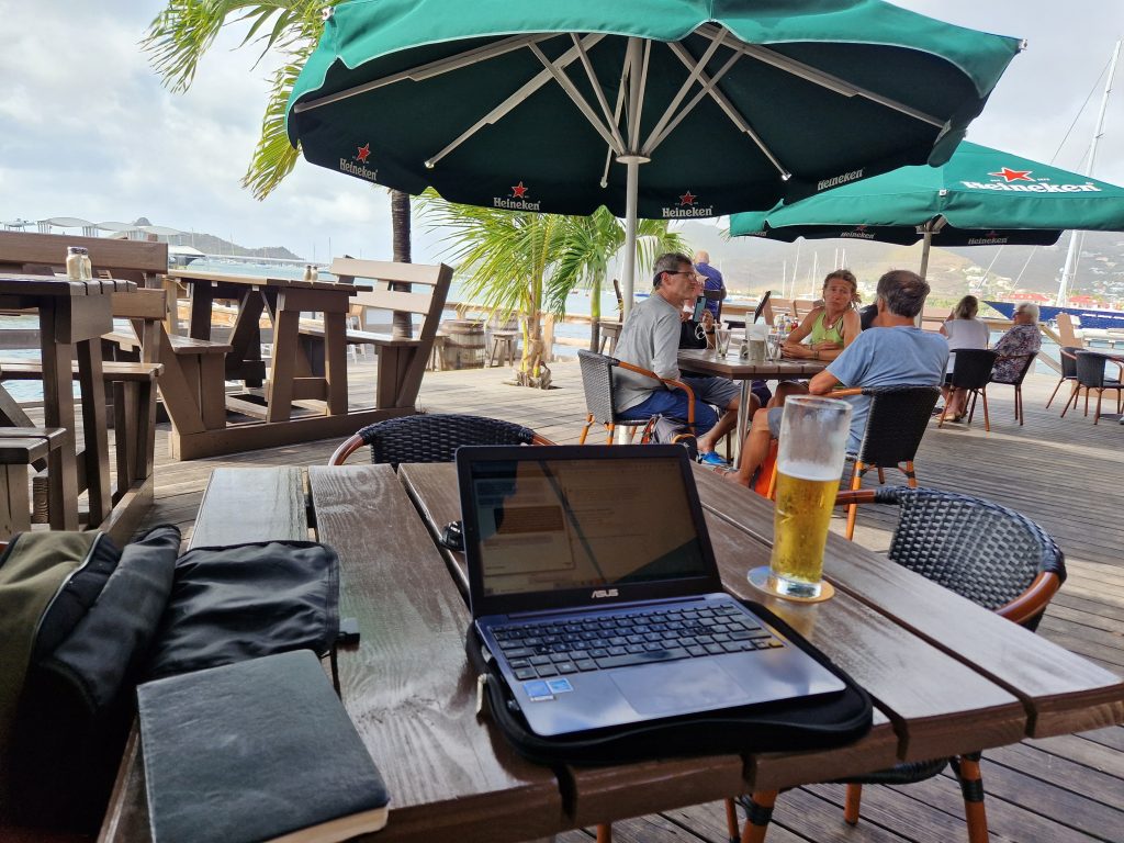
Not that I’ve actually seen it, of course. I’m sitting here in Deadman’s Bay in The Virgin Islands, and the Amazon delivery man doesn’t call here.
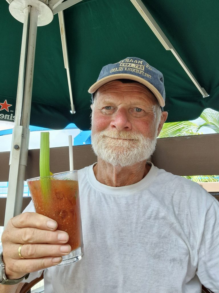
This is very clever of them: The wifi code is BUYMOREBEER – and you do feel obliged to, sitting on the deck under the Heineken umbrella trying to get to the British Virgin Islands.
The way things were going, It looked as though I might never reach the thousand palm-fringed anchorages and miles of white sandy beaches and some of the best snorkelling in the world. Originally, I didn’t intend to. I was going to Anguilla instead, which is just as nice but has contrived a series of charges designed to dissuade the charter fleets.
In the Virgin Islands, chartering is such big business that many of the vast catamarans in the glossy brochures no longer come with masts at all (if the clients aren’t going to put up the sails, why go to all that expense…)
And so I arrived in Anguilla’s Road Bay after the overnight sail from Martinique. I hadn’t even got the sailcover on when Customs & Immigration called on the VHF to ask why I had not filed my documents at least 48 hours before my intended arrival – oh, and by the way, if I set foot on the beach, they would fine me $200 for not having a negative COVID test.
Martinique hadn’t wanted any of that (and I didn’t even know I was going there until I arrived). So, I pulled up the mainsail again and sailed over to Anguilla’s larger neighbour, St Martin. One thing I have learned is that, the bigger the island, the smaller the bureaucracy.
St Martin is the French side. The Dutch side is called Sint Maarten – another of those lovely Caribbean stories: Apparently, the two nations had occupied opposite ends of the island and, not being terribly keen on fighting over it, decided to have a Frenchman walk from the north coast and a Dutchman walk for the south coast. Where they met, that would be the border.
So far, so good. It was just that the Frenchman was armed with a bottle of wine and the Dutchman with a bottle of Bols gin – and gin being somewhat stronger than wine, the Dutchman lay down for a kip some time before the Frenchman – and so the Froggies got the lion’s share.
Also, it meant I had to row all the way across the lagoon to the French side so I could use my Martinique SIM card. I had baulked at buying a Dutch one (so far I have Lebara from the Canaries, Africell from the Gambia, Unitel from the Cape Verdes and two different kinds of Digicell for the Caribbean – as well as dear old UW from the UK.)
That’s why I ended up on the Yacht Club’s wifi. The trouble was that the longer I spent online trying to make sense of the forms, the more beer I had to drink to keep the connection going – and the more impenetrable the BVIs Health Declaration form became. I had my negative COVID test – acquired from a man sitting in a van across the road – but could I find anywhere to upload it… unless that was part of the SailClear form.
Yes, that worked – except that every time I clicked “submit” a window popped up saying: “You have not uploaded health declaration forms which is mandatory to fill and upload for every individual who is arriving BVI.”
By this time I had downloaded four half-litres of Mr Heineken’s finest – which might explain why I gave up the whole idea and resolved to sail straight back to England in a huff. It might even have had something to do with my falling into the harbour on the way.
I woke up this morning to find dinner still on the table – that portion of it that wasn’t all over the floor.
After addressing the ship’s company on the evils of drink, I returned to the table under the umbrella and ordered something called a “Heineken 0.0”. It comes in a beer bottle but in fact is a fizzy concoction tasting almost exactly unlike beer. The good news is that you tend to drink it a lot more slowly.
Three hours (and three bottles) later, I had dealt with the health forms, confirmed that I had no infected crew members, stowaways, firearms, ammunition, animals or financial instruments and rewarded myself with “The best Bloody Mary on the Island”.
It’s such fun, writing this blog: You throw out a story like a seed in the wind – and back comes a saga.
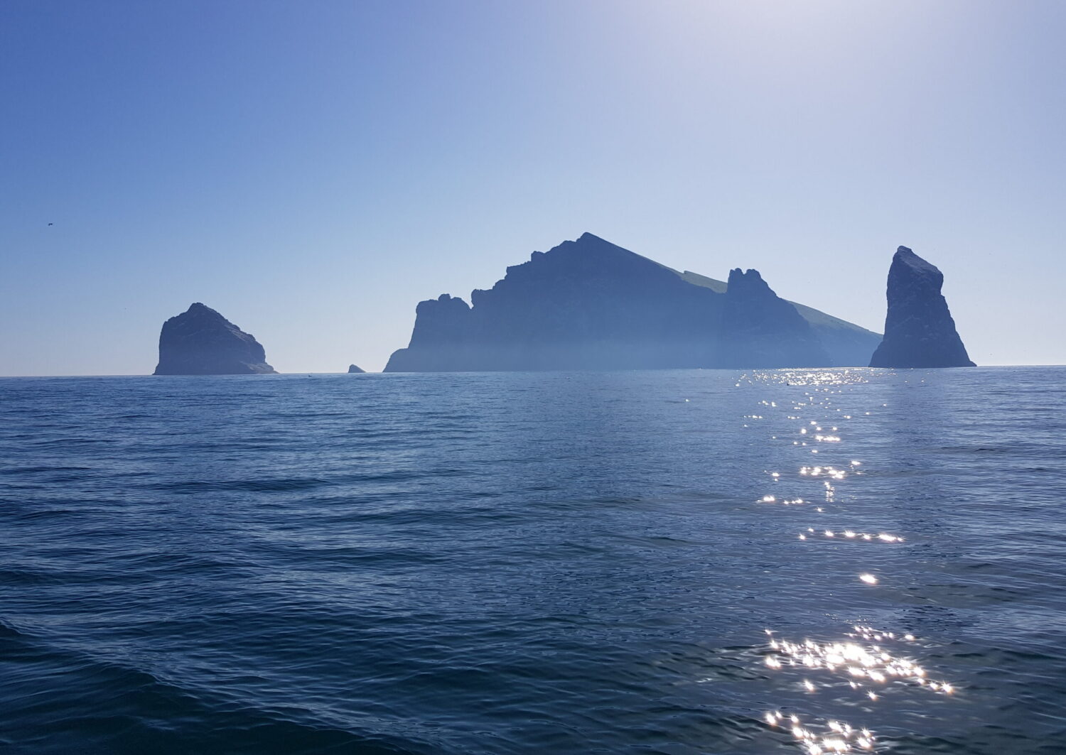
This is Diamond Rock. It looks uncannily like Rockall, except that Diamond Rock is a lot bigger – 175 metres. Also, it’s much more important: While Rockall only manages to extend UK waters out into the wastes of the Atlantic, Diamond Rock brought down an empire.
Here’s the story, courtesy of Chris Doyle’s Sailor’s Guide to the Windward Island, a little bit of Wikipedia – and my sister Carol (she of the stepped-on face in the 1960’s Folkboat).
In 1804 the British navy jealously guarded its control of the Caribbean and made a point of harassing shipping calling at the French island of Martinique. Indeed, when they could spare the odd frigate, they would blockade the capital, Fort de France.
The trouble was that ships were scarce, and the navy was busy. Then a Lieutenant William Donnett, a bright young officer in the mould of Horatio Hornblower, decided that since Diamond Rock was more or less in the best position for a British ship blockading the harbour, why not put some guns on the rock and dispense with the ship?
The fact that the rock was precipitously steep, totally barren and infested with the poisonous couresse grass snake did nothing to put off the tenacious young officer. Soon “HMS Diamond Rock” had a two 18 pounders on the summit and two 24 pounders sited in caves halfway up – together with a complement of 120 men and two lieutenants.
Water and supplies came from the main island, where the local population were happy to do anything to upset their French masters, and for 18 months, the “stone frigate” was a highly unpleasant surprise for unsuspecting shipping.
And all of this would be an interesting side-note to the naval history of the Caribbean were it not for the fact that Martinique just happened to be the birthplace of Napoleon’s Empress Josephine. It turns out she was born on a 200-acre, 150-slave estate on the other side of the bay from the capital. Consequently, the Emperor was more than usually incensed by the British impertinence and ordered Admiral Villeneuve to go and take back the rock – and destroy Nelson while he was about it.
Napoleon had it in for Villeneuve because the French navy never seemed to do as well as the French army (nothing to do with Bonaparte’s total lack of understanding of maritime matters, of course). Anyway, he ordered the admiral to report in disgrace.
Villeneuve’s forces managed to re-take the island – after an intense 70-hour battle which ended only when the British ran out of water and ammunition. But that still left the admiral with the problem of what to do about Nelson. He knew his fleet was ill-prepared for a full-scale engagement but, preferring death to dishonour; he met Nelson at Trafalgar.
The irony is that Villeneuve survived while Nelson died.
And although Napoleon’s empire collapsed about him, Martinique and Diamond Rock remained French to this day. Of course, there’s a lot more to it than this – I’d better admit to that now – before squadrons of naval historians embark on a campaign of correction.
But they may not know about the cheeky assault on French sovereignty 150 years later. This is where my sister Carol comes in.
She tells me that her husband John Guthrie, sailing to the island with a friend in the 1960s, scaled the rock and left a union flag flying impudently from the summit.
It was a while before the French authorities noticed – apparently, they were not best pleased with having to mount an expedition to remove it.
It is about 200 miles from Grenada to Dominica. It took me four days, and I ended up in Martinique.
That’s the good news. It could have been Venezuela.
The other news is that I found the Caribbean Current.
Of course, I knew all about the Caribbean Current. It gets a whole page to itself in the pilot book, which says it travels generally from southeast to northwest and can flow at up to two knots in open water.
“Generally” is the operative word here. The rest of the page seems devoted to saying that nobody is really sure, and you just have to watch out because it can appear almost anywhere at any time, going in any westerly direction, especially between April and June.
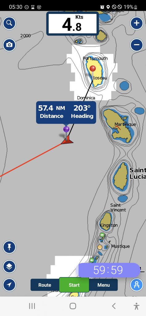
Well, thank you very much. This information I had filed away as mildly interesting and possibly relevant if it happened. Then I woke up at two o’clock in the morning to find the boat becalmed. Out of habit, I looked at the plotter on my way to the cockpit – and was startled to see we were doing 4.8 knots on a course of 203° magnetic.
Now, 203° is southwest. As you can see from the screenshot of Navionics on my phone, there is nothing in the 203° direction until you hit the coast of South America … which is undoubtedly what we would be doing if things went on as they were.
I couldn’t believe it. Where did 4.8knots come from? Nobody mentioned 4.8 knots. I checked both phones. They agreed with the plotter. I took the screenshot in case all of this was some sort of bizarre nightmare, and I would wake up and have to convince myself I hadn’t been dreaming.
Worst of all, when the wind did come back, as it always will, it would be the North-East Trade Wind which – as its name suggests – is from the northeast, and I cannot beat into that and a 4.8-knot current at the same time. I would just go backwards and get very cross doing it.
This was serious stuff. I was 57 miles from my destination in Dominica. I did have 50 litres of diesel, but that would last only about 20 hours hammering away at five knots through the water – and that, I calculated miserably, would give me a speed over the ground of 0.2 knots which would take 285 hours (or put it another way, nearly two weeks).
By that time, I would have to start rationing the water. I forgot to mention this, but I hadn’t filled up before I left. There didn’t seem the need since this was supposed to be just a quick hop up the island chain.
I started the engine – after all, every minute without it put us another cable in the direction of somewhere called La Esmeralda.
The next screenshot shows the situation as we headed for the nearest land – Martinique, 36 miles to the northeast. At our most economical 2,000 revs, you can see the speed over the ground is 0.00kts. In other words, we are standing still. I wound up the throttle to 2,500rpm. At that speed, the little Nanni 21hp guzzles fuel, but there was no point in going nowhere. Gradually the speed over the ground crept up to 0.8kts.
Thirty-six miles at 0.8 knots is 45 hours. We would run out of fuel long before we got there, but my theory was that the nearer we came to the lee of an island, the weaker the current should become. Anyway, 4.8 knots had to be some sort of aberration.
It wasn’t. Or if it was, it was a particularly persistent one. As the sun came up and with it the wind, I still felt as though I was trying to swim up a firehose. Any attempt at sailing sent us whizzing off backwards. The only way to make any progress at all was to keep the nose dead into the current – and, of course, the wind. I put the flattening reef in the mainsail and sheeted it almost dead centre. The headsail was useless, of course.
And then the engine stopped. Within an hour, we were back where we had been at two o’clock in the morning.
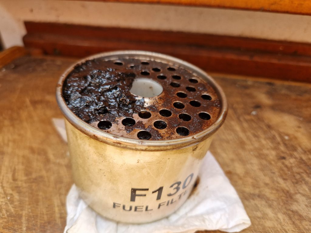
It took an hour (in fact, it took three) because not only did I have to change the CAV filter, which looked as though it was full of caviar. In fact, this was diesel bug – something I suffer from particularly because I don’t use the engine nearly enough. The fuel just sits in the tank, growing things.
Also, I don’t inspect the filter often enough. My excuse is that I can never get it back on without it dripping diesel into the bilge. This time I had to re-arrange the seals three times.
The other reason it took three hours was because it wasn’t just the filter that was blocked. The pipe to the tank was full of goo as well. Blowing it out was like volunteering for the trombone section at Beyreuth.
It wasn’t until the middle of the following night that the speed started creeping up – I have never been so pleased to find the boat doing 1kt. The question was: would the fuel hold out long enough to get us into the lee of the island and able to sail again?
Meanwhile, what startled me most was thinking about how this would have played out in the old days before satellite navigation. I wouldn’t have known anything about it until two o’clock in the afternoon and the “midday” sunsight. The morning sight would have given me a position line running northeast to southwest but I would have had no clue where I might be on it until I got the intersect – by which time it would be twelve hours after I had woken up to find the boat becalmed … and another 57 miles in the wrong direction.
I could imagine myself saying: “Sod it: let’s go to South America.”
Of course, in the end, I did make it into Martinique – gradually making more and more progress until l turned off the engine when we were down to the emergency can of diesel for motoring into the anchorage. After that, it was just endless tacking back and forth and gradually creeping closer and closer until the enormous Bay of Fort de France opened out with the “largest and liveliest city in the Windwards” climbing up the hill.
Look on the bright side: I would never have come here if it hadn’t been for the current – in fact, I would never have turned to the Martinique chapter in the book at all – in which case I would not have learned about Diamond Rock just around the corner and how it changed the course of European history.
That’s the best part of pilot books; they tell you stuff you really need to know – in this case, a swashbuckling tale of intrigue and adventure involving Napoleon, Josephine and Lord Nelson – instead of vague predictions about ocean currents.